|
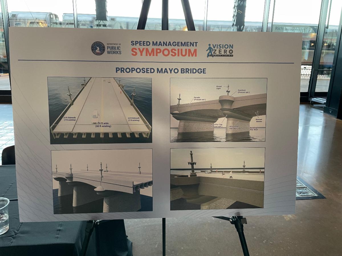
While the wider sidewalks are a positive feature in the new design, the design falls far short of what’s possible. In fact, the high-speed four lane configuration without protected bike lanes is at odds with the city’s commitment to increased safety on our streets. It would also be a lost opportunity to knit together two of the cities most important and revitalizing neighborhoods, Manchester and Shockoe Bottom, with a green, bike and people-friendly connector to serve the thousands of new residents living in these historic neighborhoods.
Under Federal law, the City and VDOT are required to host a Section 106 consultation process under the Historic Preservation Act because of the impact on a historic resource. To our knowledge, this has not taken place yet. It should, and it will also allow time for the city to hear from residents who would like to see other design options:
- One option could be one car lane in each direction, with a roundabout on Mayo Island. With nearby, oversized Manchester Bridge available, commuters will have that as an alternative for entering and leaving the city.
- At the same time, we have to consider our bus network and this is the route for the GRTC #1’s. Converting one of the two car lanes in each direction to a dedicated bus lane and part of the sidewalk to a protected bike lane would be another option.
Take Action – Email the Mayor to request a safer design for Mayo Bridge!
Suggested comment to the Mayor:
Mayor Stoney, the proposed design by VDOT and DPW for the Mayo Bridge is very disappointing. It does not include protected bike lanes, and allowing four lanes of traffic on a new bridge will increase speeding and put pedestrians and cyclists at risk. It is contrary to your goals to make our streets safer amid so many traffic deaths on our streets. I urge you to pause the project to allow for public discussion and input, and development of a greener, safer, more people-oriented connection between Manchester and Shockoe Bottom. Protected bike lanes, dedicated bus lanes, two car lanes instead of four, and traffic calming features should be evaluated and added.
Replacing Mayo bridge is a once in every 100 years opportunity for our city, and we must ensure it’s not like a highway bridge, but instead a green, people-friendly connector, knitting together our city – with a priority on people walking, biking, and taking transit.
Thank you,
(signature)
|